Tuesday, June 14, 2011

shopping village

The winds have been extremely strong. This means that we’ve had some days that the waves were raging so fiercely that we could not go to sea. It also has meant that the shipment of food and drinking water has not been able to come to our station for over a week. Luckily Yellu is nearby, a relatively large village with a large green mosque and an equally impressive telephone mast. The village predominantly houses workers from the nearby pearl farm. The income of most people in this area appears to be from the pearl farms that stretch over kms. of sea. Yellu is where all the passing ships and boats stop to get supplies – and it’s amazing what you can get here in this middle of nowhere place. We would often stop by on our way back home mostly to pick up some water, some Oreos and mobile phone credit. SO everything is available, except fruit and vegetables and nothing is in definite supply. One day we went by to find that all stores were out of water, not a bottle to be found – a couple of big boats had just come by an hour before and cleaned them out….

When the boat from Sorong finally did come containing our order of freshness, we were thrilled with happiness. After ten days of Indo-Mie, rice and salty dried fish for every meal, vegetables and fruit never tasted so good!

Saturday, June 11, 2011

Hi!

Just got back from Misool and once again within the reaches of the internet. We've put up some posts about the fieldwork and will add more in the next weeks when we have a better connection.

Enjoy,
Lisa

Wednesday, June 1, 2011

lake entries

Equipped with coordinates and distant aerial pictures, we never quite know what to expect when rounding the last corner before the estimated entry point of an unexplored lake. More often than not, after gliding over gorgeous shallow water coral reefs, our boat comes to a halt in front of a seemingly impenetrable wall of sharp limestone covered in thick rainforest. Undeterred, our trusted guides Jams, Ali and Hassan go out to scout the area first, machete in hand, to find out how realistic it is to access the lake, having gained a good impression of what we ladies are capable of. After anything from a few minutes to almost an hour, they suddenly resurface out of the jungle. The ensuing conversations usually consist of a variation on the following themes:

  • “bisa?” “bisa!” (can? can!)
  • “bisa?” “tidak bisa... too high!” (can? can’t... too steep!)
  • “bisa?” “mungkin bisa. jau sekhali... setengah mati!!” (can? maybe can. very far... half dead!!)
  • “bisa?” “bisa... tapi air tawar.” (can? can... but it’s fresh water.)

Once it has been established that a lake is accessible and marine, we start our ascent into the unknown. Each lake entry is a different adventure with its own character and challenges. Some come with muddy slopes or sharp lose rocks, others require advanced climbing skills, some make us feel like Tarzan’s Jane as we swing from one tree to the next, while others have us mildly worried about the diseases we might be exposing ourselves to while wading through smelly swamps.

But as the lakes come into view we are always rewarded with magical sceneries, each lake beautiful and peaceful yet unique. In some cases we are probably the very first people to set our eyes on a particular lake, and this knowledge raises a strange feeling, suddenly being struck again by how privileged we are to be out here.

Our scientific instincts soon take over, and we start scanning the edges to determine what type of fauna and flora dominate the lake. This includes critically examining every log-like object from a distance, and hoping that everyone agrees that it is “kayu” (wood) and not “buaya” (crocodile). Indeed, although we have been made aware of emergency procedures in the not completely unlikely event of a crocodile attack (they like hanging out in brackish waters), we would rather not find out whether we are any good at hitting a crocodile on the nose with a miniature rake, poking a dive knife into its eye or even safer hopping onto its back.

Once we are confident enough that the coast is clear, we slowly slide into the water in order not to stir up the sediment. Each of us will spend the next few hours completing their part of the lake survey, such as tracking its shape and dimensions, performing sponge community surveys or recording water parameters. More on this in another blog entry.

Lisa and Cat


Wednesday, May 25, 2011

lake exploration equipment

Lake exploring, in line with most other outdoor adventure activities, requires highly functional, specialised and technical equipment. Needless to say, this equipment has to be extremely versatile, as it must not only be optimal for snorkelling, but also for lake entries through very treacherous terrain, such as climbing over limestone cliffs and carving a path through the jungle. After years of research and development, Becking Inc. is proud to present the ideal outfit that fulfils these highly varied requirements:

  • dive booties, preferentially with sturdy anti-slip soles for these slippery slopes and rocks. However, no sole is infallible, so one needs to have handhold security as well. This is why the next piece of equipment is:
  • gardening gloves. Ideal for climbing on razor-sharp limestone cliffs, but also to grab onto these vines that may just turn out to be snakes, and to be able to confidently hold on to the next tree that is more often than not covered in aggressive ants. Further protection against the creepy-crawlies is provided by one of the most crucial elements of the lake-explorer-equipment:
  • the wetsuit. No mosquito can pierce through this barrier, and the padding ensures that the only consequence of an unfortunate slip is an ugly bruise, and not a deep cut that could rapidly turn into a dreadful infection in tropical environments. Obviously, the wetsuit also provides protection against hypothermia (for these long hours spent in the waters of the lake), against marine stingers (one is never cautious enough when entering unchartered waters) and against sunburn. The wetsuit unfortunately does not yet provide protection against overheating during those strenuous jungle hikes, so one should never forget to bring a water bottle. This will fit into the next piece of equipment:
  • the backpack. Bash-able, wet-able and scratch-resistant, the backpack needs to have a capacity of about 40 to 50 litres, to contain the rest of the snorkelling equipment, all the research equipment, and the photographic documentation equipment. Ideally fitted out with specially adapted fin-attachment devices, one must also be able to somehow attach a floating ring to it, to minimise physical exertion during those long hours spent exploring the waters of the lake.

Many optional add-ons are available, e.g. hats and hoods, machetes and dive knifes, ropes and homemade ladders, as are variations on design and colours. For further information do not hesitate to contact Becking Inc., or consult the illustrated 2011 catalogue (excerpt below).


Saturday, May 21, 2011

mapping out the lakes

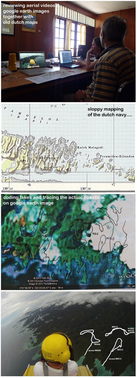
The day after the flight we sat down with Max to thoroughly review the aerial pictures together with the video images that Max took of the flights and compare these with the available maps and Google Earth. The flight turned out to be no unnecessary luxury as neither the Indonesian nautical maps, nor the old dutch maps showed any of the complex detail of Panah Panah – the cartographers sufficed with indeterminate blobs that had little correspondence to the actual complexity of the island’s coasts. As for Google Earth, the satellite images available were of low resolution providing little accuracy as well. Luckily with the videos Max was able to draw an estimate of a coastline – so does this mean we may be the only ones who have a truly representative map of Panah Panah?

Taking lake by lake, we made a database of coordinates and access pictures per lake, drawing the optimal entry paths from sea and over land. It took a whole day, but it meant that we have all we need to let the lake hunting commence!

Friday, May 20, 2011

aerial survey


Right after the 9 hour boattrip (see previous entry!) from Kri to Misool I jumped into the bright yellow lightweight water airplane with Max Ammer - still soaked and shivering from the boat, but thrilled to have the chance to fly again in Raja Ampat. This flight was made possible by a generous donation of 2 hours flight time by Conservation International in order for us to survey the Misool area for lakes. We took off right in front of the TNC Misool station in Harapan Jaya village, flew north to the Selat Panah Panah (the Strait of Spears), then made a circle crossing east over the 100s of scattered islands that make up Panah Panah & Wagmab, south to the island of Warakaret, west over the islands of Kalig & Karawob, then back up again to the TNC office. It was a magnificent flight, what a spectacular view! The open airplane gives you a true feeling of being part of it all.

The jutting karst landscape so typical of this part of the world, never ceases to amaze. Every island is a different shape, some just specs of land shaped like mushroom heads appearing to float on the water. This kind of heterogeneous topography with many hills, bays and depressions inland is the ideal place to locate lakes. And indeed we couldn’t believe our luck, the lakes never stopped coming during the flight, Max was continuously pointing them out – it was hard to keep up with the recording. I record the lakes by marking the location on a GPS when we fly over one, then make as many pictures as possible of the lake and particularly of the surroundings, after which I make a picture of the GPS to facilitate the linking of the coordinates with the lakes. The pictures of the surroundings are important in order to figure out the best was to access the lakes by boat and subsequently by land. That will be the job for tomorrow. For now I’m still riding on the high of the flight, the trying boat ride from Kri almost a distant memory.