The day after the flight we sat down with Max to thoroughly review the aerial pictures together with the video images that Max took of the flights and compare these with the available maps and Google Earth. The flight turned out to be no unnecessary luxury as neither the Indonesian nautical maps, nor the old dutch maps showed any of the complex detail of Panah Panah – the cartographers sufficed with indeterminate blobs that had little correspondence to the actual complexity of the island’s coasts. As for Google Earth, the satellite images available were of low resolution providing little accuracy as well. Luckily with the videos Max was able to draw an estimate of a coastline – so does this mean we may be the only ones who have a truly representative map of Panah Panah?
Taking lake by lake, we made a database of coordinates and access pictures per lake, drawing the optimal entry paths from sea and over land. It took a whole day, but it meant that we have all we need to let the lake hunting commence!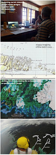
No comments:
Post a Comment